We left the Torrey, UT area at 8:32 AM and by 1:00 PM or so we were south of Cedar City, UT setting up camp at a BLM dispersed camping area.
Nice spot, and no neighbors which was the best part. Even the wind, which wasn't that strong, was warm under the bright sunshine once the clouds moved away.
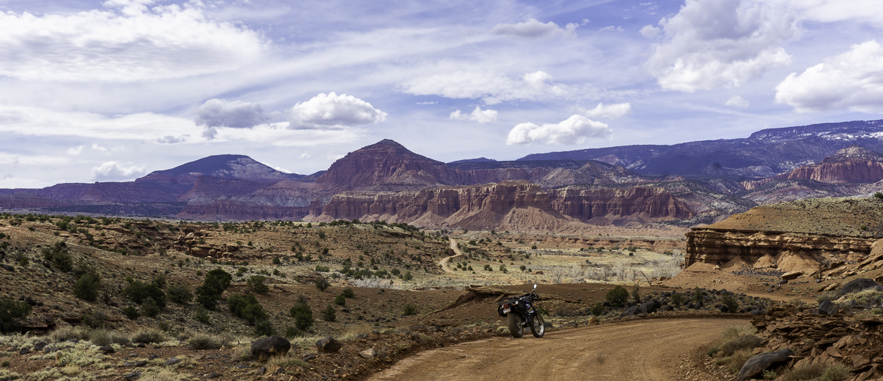
We rested and relaxed the afternoon away, enjoying the warm conditions. I did take Yagi, the T-Dub for a short ride in the trail loop nearby, but nothing pic-worthy was found.
Tuesday, April 23
Martha and I took Harriet, the CR-V, south on the highway for about ten miles to the exit for the Zion National Park's Kolob Canyons Visitor Center.
pic by Martha
After Martha got her Park Passport stamped, we drove onto the scenic road which takes you to an overlook trail. It was a mile to the end and not too hard, perhaps 100 feet in elevation change.
The trail takes you up to some rather nice views of the nearby Kolob Canyons. You can, pretty much see the canyons from the trailhead parking lot but we needed the exercise, so....
Martha walking back towards the trailhead...
We weren't there at the best time of the day in
terms of sunlight but we made do...
Shuntavi Butte
We returned to camp where Martha dropped me off and she went shopping at nearby Cedar City, for groceries.
Not much got done otherwise in the afternoon, I did a minor repair to the left rear mudflap on the VRRV which had once again been found hanging by one screw!
Martha and I drove the Honda CR-V (Wanda) down UT Highway 12, a designated scenic byway, towards the Escalante National Monument.
A brief stop at "The Hogback" for the above shot.
The rest of the photos for this post are screen captures from the footage shot by the car's dashcam. Not too bad. There are some really cool and colorful rock formations as one heads towards and through the Escalante National Monument enroute to its visitor center in the town of Escalante.
I've been in this area on previous trips and rides: LINK1, LINK2
Martha got her Parks Passport stamp at the visitor center and I wandered around reading info placards and admiring the giant lizard:
That'd be something, wouldn't it,
if they were actually this large.
The drive back was without issue and without success in terms of securing pie at the Burr Trail Grill (they were out) and at the General Store and Bakery in Torrey, UT!
Sunday, April 21
A lazy morning where nothing was accomplished except for shots of nearby rock formations visible from the campsite:
After lunch, I rode out on Yagi, my Yamaha TW200 to explore the forest roads north and west of Torrey, UT which are in the Fishlake National Forest. A short hop on UT24 and soon I was on dirt and having a good time.
I found a trail which led to the rim of the mesa I was riding on...
I wandered about, checking out trails, finding lone campers and generally enjoying the riding conditions. Some spots were full of large rocks embedded into the trail but even those weren't too bad or technical.
Let's see, I check out parts of FR 146, 1597 and 1584. The last trail took me further west to the vicinity of this cool looking rock formation:
Here's the best looking, IMHO, rock formation for this area. There was a lone camping rig here, a converted FEDEX type panel truck, but I hid it behind the bush.
I made my way back to Torrey with only a couple of wrong turns. Lots to explore in this area, will have to do more riding of it if ever camping in this area again.
I got back to camp with no issues, saw several rigs moving in trying to find themselves a spot. Packed away most of the outside gear in preparation for displacing tomorrow.
This morning we drove down to the vicinity of the visitor center for the Capitol Reef NP and checked out the Petroglyph Panel.
Our view of nearby Torrey and the rock wall overlooking the town:
This is a section of rock wall where petroglyphs are evident. They're pretty cool, though thoughts of ancient astronauts did briefly fill my head. The artwork is quite faded now, in fact, Martha had to point the first one below out to me.
The below pics have been enhanced to show the figures better.
There's a wooden walkway to guide you along the wall, and to keep people from actually disturbing the petroglyphs.
We then drove about 25 miles or so to the eastern entrance of Cathedral Valley BLM area. The western entrance involves a small river ford and not usable by regular vehicles like the Honda CR-V we were driving.
17 miles later on mostly easy dirt roads, we arrived at the turn off for the Temples of the Sun and Moon. Big, impressive rock formations jutting out in the middle of the valley.
I've been to these formations and valley before: LINK, LINK2 with my Ural sidecar rigs. This trip was to introduce Martha to the rock formations. The rock formations are part of the Capitol Reef NP by the way.
We returned to pavement with no issues save having to deal with a group of bicyclist that had a clueless driver for their SAG wagon. Guy kept parking the truck with trailer on the trail, blocking traffic!
After a late lunch, we made a shopping run to the small town of Loa. On the way, we stopped at a auto parts store in Bicknell, UT where I managed to find a suitable bolt to secure the left mirror mount on Yagi, my TW200.
Surprisingly, it had been impossible to find the OEM bolt at no less than five hardware stores in Moab. So, I used a longer Hex cap bolt instead, and it works fine.
A short test ride to make sure the mirror was firmly mounted was of course required:
Martha and I drove over to the Capitol Reef NP's Visitor Center located just off the UT24 Highway about six miles east of Torrey, UT.
After getting her Park Passport book stamp and a map, we drove onto the Scenic Highway deeper into the park. First, a stop at the Gifford Farm where a museum and store is located. Mainly, to get a pie sample.
The drive into the scenic highway's rock formations was "into the sun" so we didn't stop for pics or use any of the dashcam video footage. We got to the end of the road where there is a small trailhead. Parking was an issue and we ended up parking in a small spot at the end of a line of parking spots. When we returned it was a cluster-f*ck of a parking area.
The Capitol Gorge Road trail is pretty level and we walked about a mile in, I think you can take this trail all the way to the small town of Notom, UT but we wouldn't be going that far.
The gorge is obviously by definition bordered by high rock walls. We were walking where water once flowed (and probably does during floods and heavy rains).
We walked past Pioneer Register where people from the past left their mark and names while transiting this area. There's also a bunch of modern era ass wipes who left their names on the rock walls. I guess they didn't see the sign stating it's illegal, after all what's historical value compared to a fleeting Instagram posting right?
Anyways, we got to the start of The Tanks trail which led up some sketchy looking terrain:
Martha of course was up for the challenge and up we went. It was signed as 0.2 miles long, the trail. It wasn't too bad but some parts required due care.
Still we made to within sight of "the tanks". You can see water collecting in one of the pictured holes below.
Here's views from the trail, a bit higher than the gorge's road bottom:
The walk back to the trailhead was without any issue, just a short stop to get a picture of layered rock that I found interesting:
We apparently were here at a good time this month. The "Scenic Road" will be closed for construction starting April 30, not sure when they'll be finished but pretty sure not for a few months.
We tilted the dashcam lens a bit for the return trip from the trail head area:
This will probably be last of this type of dashcam video, lots of time to convert/edit. (the crowd cheers...)
A bit past 3:00 PM, I went on a ride on Yagi, my TW200. I just rode what trails were available around the campsite area. Found that Sulphur Creek Road leads one into the Capitol Reef NP a short ways before it meets up with the US 24 Highway at Twin Rocks:
The afternoon had turned mostly cloudy, leading to some dark lighting for the landscape, but still it was OK as I retraced my route back towards camp:
I even found a small water crossing along the way:
I wandered out of the camping area and found another BLM gate to the ridge next to our campsite's ridge. I wandered for a bit but there wasn't much riding to be done before one ran out of trail and faced the edges of the eroded ridge.
Still, one spot gave a good view of the two prominent mountains to the west near Torrey. The one on the right is unnamed according to the Peakfinder app. The one on the right is called The Ant Hill. I would have thought the unnamed formation would be called Ant Hill but what do I know.